*Writers note – Sunnyside is a touchy subject, and people on both sides of the argument are passionate, hard working and integral parts of our community. This article is an unbiased piece meant to present the situation for public discussion. Disrespectful comments will be deleted. It’s a long read; dig in.
The Quiet, Three Year Fight Over Sunnyside
With its southern exposure and earlier snow melt, to many locals the slopes of Mount Mackenzie have long looked like an ideal place to develop bike trails. It’s a notion that has grown legs and taken off. The Revelstoke Cycling Association (RCA) is currently in the process of developing an area called “Sunnyside.”
 The biking community of Revelstoke, as well as raising the community’s profile in the tourism sector, offers the town an economic benefit in furthering our ‘four season resort’ name. At the same time, Sunnyside has created a layer of division that has come to a head between multiple households south of Catherwood Road, Recreation Sites and Trails BC (RSTBC) and the RCA.
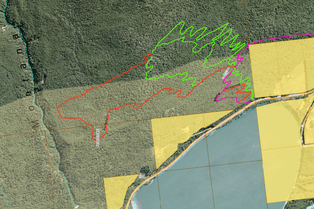
A section of the lower slopes of Mount Mackenzie, which will be utilized to access the Sunnyside development, acts as the Montana domestic watershed for residents who have water licenses in the area. Recently, eighteen households (not all of who are water license holders but are below the trail development), about the same number of homes who were previously affected by the Thomas Brook water issue at Revelstoke Mountain Resort (RMR), petitioned the Mayor, Member of the Legislative Assembly (MLA) Clovechok and Minister Donaldson to reconsider the development.
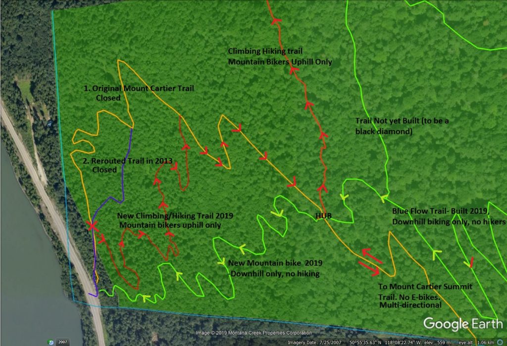
Discontent can be traced back to 2016, when local residents lodged a letter of concern regarding the proposed trails. These residents had, in 2015, noted unauthorized trail building, partially on private property, and learned of the RCA’s proposal to develop the area with what residents believed to be one looped track called Sunnyside. Worried about their watersheds due to trail locations and possible unauthorized trail short cutting, they requested the RCA consider building two legs of trail cutting from the historic Cartier Trail south to McKay Creek to access the new trail, versus one longer trail over their watershed. Ultimately, the proposal turned out to be more than one track, and RCA decided against utilizing a different access point.
“Numerous trail lines were walked by a number of different trail consultants and RCA board members over the course of the multi-year planning process. There are many reasons why this particular spot was chosen – the terrain, the sustainability and longevity of the trail, the grade, and the access. The trail was rerouted throughout the planning process based on input from consultants and residents, and ultimately the current path of the trail is a result of extensive planning and consultation between a number of parties,” explains a representative for the RCA about the decision.
This, in turn, precipitated two years of back and forth between RCA, water license holders and RSTBC.
In the initial RSTBC officer’s proposal report, the RCA was noted as saying trail building would have no impact on watersheds. Water license holders contended the RCA lacks the expertise to make such a call. After two site visits with RSTBC and one visit with two hydrologists, the required up slope distances from water intakes went from 15 meters to 100 meters in an effort to appease all parties. The 100 meter mark is also mentioned in ‘Revelstoke and Area Land Use Plan.’ (pg 37)
Water license holders feel their watershed has a high risk for contamination, and that, in the case of water contamination, the water license holders were unlikely to ever be serviced from the City of Revelstoke. In the event of contamination, the costs of repair could be prohibitive.
“Is the RCA willing to pay for it?” one resident asks.
Additional concerns include parking for a high use trail network. Privately owned property, affected residents note, could create issues with the development of adequate parking and outhouse facilities. The RSTBC has since created a parking plan and will be installing an outhouse, though the location was not available to the Revelstoke Current.
Watershed Management in the Revelstoke District, written in 1999, has suggested best practices for domestic watersheds. They include “the construction of recreation facilities within riparian management areas should be avoided whenever possible.” (pg 95)
The document also recommends that “for forest activities, riparian management in domestic watersheds will be determined by the Riparian Management Guidebook with one important exception. Streams licensed for domestic use which are classified as S5 or S6 under the guidebook, will be managed as S4 streams for a distance of 500m above the most upstream domestic intake.” (pg. 92)
If applicable, it would require massive trail realignments to meet the 500m up slope minimum distance. “This is why we have been asking for discussion,” says local resident Janis Hooge. “This could have been addressed in the planning stage. It would have been cheap to make changes then.”
There are, she believes, locations with less potential for conflict to build. These include 12 Mile, Drimmie Creek and the Echo Lake area.
A representative from the RCA explained the RSTBC were not supportive of an Echo lake development for a number of factors. They included snow levels, distance from town and logging. Meanwhile, Mount Mackenzie is unlikely to see any significant logging, an issue that has plagued the RCA in the past.
Though sympathetic to the RCA’s desire to grow their trails and a biker herself, Hooge maintains that, while dealing with logging companies might not be a fun experience, domestic water sources in the area around Revelstoke are not so numerous nor so spatially extensive that avoiding them really puts a significant constraint on potential recreation areas.
Consumptive use watersheds make up only an estimated 6 percent of land area in the Revelstoke region.
While watersheds are vital, it is important to know what a domestic watershed is. Basically, it is a water license for a residence not on city services. Water is taken from springs or streams from an intake and stored in tanks. Property owners pay a yearly fee for their license. Unrecorded watercourses in the ‘Montana Face Domestic Watershed’ are not within the drainage for either Montana or McKay Creeks, but springs/creeks that run down directly into the reservoir, or travel underground to get there. The whole slope, similar to that at the RMR, has a lot of subsurface water and the exact course of water underground is unknown. While there are rules and policies in place to protect watersheds, if policy is followed, licensees ultimately have no say about what happens up slope of their intake.
Wayne Stetski, the local Member of Parliament for the NDP party, had a straightforward and realistic answer regarding the development of watershed areas.
“Rightly or wrongly, BC has a history of allowing a number of activities in watersheds that provide drinking water. It has ranged from cattle grazing to logging to recreation. The question (of developing watersheds) has two sides to it: 1. You need to determine what potential the proposed activities have to negatively impact the quality of the water as determined through science and 2. What activities are acceptable from the community’s perspective?” he says. “Both need to be considered before decisions are made on what activities should be allowed in community watersheds.”
One homeowner, speaking on condition of anonymity, said the following.
“We aren’t asking for infrastructure for our water supply, all we are asking is that it be protected the way policy indicates it should be.”

Policy manuals contain hundreds of pages of recommendations, ideas, and best practices. With keen eyes, both parties could likely find what they are looking for within their pages.
While the homeowners affected by the trails may be justified in feeling frustrated by feeling unheard or ignored, the RCA has worked with and has the support of RSTBC.
 Between 2016-2018 the RCA began taking the steps necessary to create Sunnyside. They worked with RSTBC and in the spring of 2018, the RSTBC Revelstoke Trail Development Plan by Cabin Forestry Services was completed. This report recommended parking for 30-40 vehicles and an outhouse. It also notes the historic Cartier Trail is better suited to hiking than biking, and recommends Sunnyside focus on helicopter drops to take the pressure off of this trail.
This report recommended these issues be addressed prior to trail building commenced.
The Revelstoke Current reached out to the RSTBC, who have not responded to comment at this time.
The land Sunnyside will be developed on is predominantly within RMR’s Controlled Recreation Area. This means the land has, for some time, been earmarked for recreational use. The potential exists for trails to connect to RMR in the future.
“We can understand that residents of the area don’t want to see increased use and traffic. However, Sunnyside is being built on Crown Land and primarily in an area that has been designated for recreation. We have followed provincial guidelines and worked with RSTBC to ensure that our trails meet their standards and that water intakes are unharmed,” says the RCA representative. “Ultimately, we have diverging goals, but we hope that residents will understand the value that this trail network will bring to Revelstoke residents.”
Doug Clovechock, the Liberal MLA of the area, notes that his office has been working with various constituents about ‘Sunnyside’ since 2017.
“The Provincial Government has a policy in place for applications like the one in question at Sunnyside on Mount Cartier,” MLA Clovechock explains. “These decisions are not about my personal opinion; everything comes down to policy. I can advocate to explore if policy is aligned with the proposed applications, which we have done, but at the end of the day, a decision like this is up to the Ministry of Forests, Lands, Natural Resource Operations and Rural Development.”
The RCA has a record for building trails and working with stakeholders to grow the biking community within Revelstoke significantly over the past several years.
Concerned residents aren’t sure the RCA is up to the task. Trail widths in the Sunnyside build are currently wider than specified. The RCA assures they are working with the RSTBC on a revegetation plan to ensure the trails stay within the bounds of their agreement. Water license holders had not been notified of the plan.
“The families that live in the Mt. Cartier area were never advised of the size and scope of the planned development,” explains resident Buck Corrigan. “A number of families get their drinking water from springs on Mt. Cartier and owners with wells below the mountain rely on the springs to replenish their aquifers.”
Andy Parkin is, in fact, a neighbour of the development.
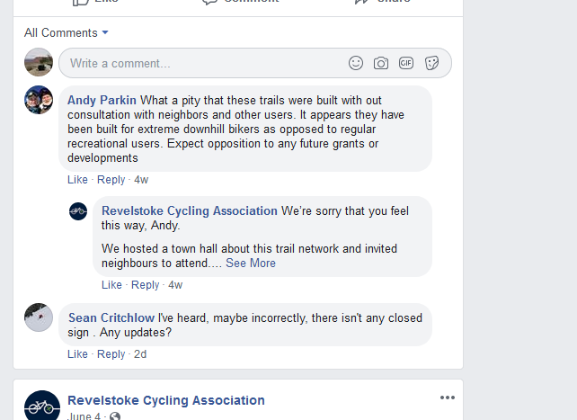
“As near as we can tell, there was no formal public consultation concerning this development. The RCA advertised on its own website that there would be a ‘Town Hall Meeting,’ but this was never advertised in the local newspapers as is the norm for development on Crown Lands,” he says. “And the residents of the Mt. Cartier area were not notified. We believe that a development of this size should be required to follow Provincial guidelines for development.”
A letter to concerned residents from John Hawkings, Director, Recreation Sites and Trails Branch, also mentions the RCA’s town meeting in April 2018 that local residents were consulted. Hooge disagrees. She and another resident did attend, but the Sunnyside trail plan, Hooge notes, was not up for discussion at the meeting and hardly qualified as a consultation.
A letter from the RSTBC downplaying the plans for Sunnyside
For water licensees of the Montana domestic watershed, there is a constant feeling of being kept in the dark.
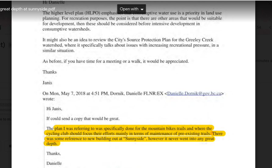
In a letter from an RSTBC representative to one licensee attempts to placate her, in the spring of 2018, writing that ‘Sunnyside’ had been discussed, but not in any great detail. At the same time, the RSTBC had commissioned their trail development plan, the RCA had created maps and started appealing to the community for letters of support.
Letters of support came from representatives from the Stoke Youth Network, the Revelstoke Accommodation Society, and Revelstoke Chamber of Commerce in the RCA’s efforts to obtain grants to help fund their development.
A bone of contention for licensees is the fact that two of the three letters written were penned by members of the RCA Board of Directors at the time. To them, this is a conflict of interest.
The RCA disagrees.
“A conflict of interest exists where an individual has a material interest in a project or activity, not when someone has enthusiasm for a project. The RCA Board is composed of hard working individuals who volunteer their time for the benefit of recreation in Revelstoke and not for their own personal or financial gain,” they explain. “We are careful to exclude board members from the decision making process if those board members stand to benefit professionally or financially from our activities. Letters of support are written for the express purpose of seeking grants and funding, and as such we seek out approval from people who are enthusiastically in support of a project.”
Local residents are not the only ones concerned over the lack of consultation. The North Columbia Environment Society (NCES) first voiced their concerns over the development in 2018 in a letter to city council, the mayor, and a local RSTBC representative.

The letter noted several concerns, including that the referral was not sent City of Revelstoke’s Environmental Advisory Committee (EAC) for review and their recommendations.
“The NCES is still very much concerned about the lack of environmental assessment, noise pollution, trail disruption, wildlife displacement and lack of consultation with surrounding residents,” says NCES Executive Director Kate Borucz.
For Janis Hooge, years of disagreements, back and forth and miscommunication could have been avoided had the RCA looked closer at developing Sunnyside while avoiding the watershed.
“We have a lot more to lose with our water supply than the aesthetics of logging affecting a bike trail,” she says.
A quick hike of the work in progress resulted with seeing nearly a dozen bikers use the closed trails in under three hours. Hikers were also out in force. When asked if they were from town and frequently hiked Cartier trail, all identified with being local and frequent trail users. All were curious. Three were worried hikers would be forced off the trails due to high bike use, two identified as avid bikers and were excited to see the build. None had heard of any public consultation regarding a bike development.
With so many stakeholders and so much passion in the mix, is it possible that Sunnyside is a project whose scope creep became a victim of poor communication and quick timelines? Is the RSTBC determined to build the development regardless of concerns? When it comes to development, there is likely to be an unhappy party, but where can we work together to mitigate concerns and move forward as a community?
In a small town experiencing growth, and doing our best to grow well and capitalize on it for the benefit of our economy, community, and own favorite pastimes, maybe if everyone was willing to bend a little, development in the future can be favourable to everyone involved.
Facebook Comments